[ clique para ampliar ]
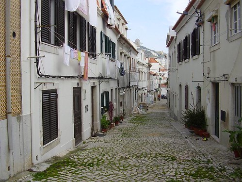
Rua 31 de Janeiro.Também conhecida como Rua de Alfenim. Aqui funcionou uma famosa escola particular, a da Rosa "Manoa".

[ clique para ampliar ]Fotografia do "Sesimbra em fotos": um novo blogue da piscosa.
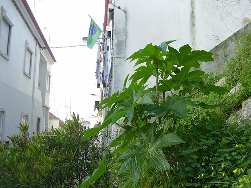
[ clique para ampliar ] Um belo exemplar de rícino (Ricinus communi-Euforbiacee) nasce espontaneamente à entrada da Rua Brito Camacho. É desta planta que se faz o intragável "óleo de rícino", que atormentou gerações de crianças.
A bandeira brasileira é um sinal dos tempos, algo que começou com a pateta moda de desfraldar bandeiras pela equipa nacional de futebol. Neste caso deve traduzir a afirmação de imigrantes brasileiros nostálgicos do seus país.
Livros da Biblioteca

Editora: Teorema
Edição portuguesa: 2006
Tradução: Paula Reis
Nº Páginas: 312
Edição francesa original: 2004
Como Napoleão não conseguiu vencer o "vespeiro português"
Francisco Neves - jornal Público
«Foram más e pouco mudaram desde a monarquia de Versalhes ao império Napoleónico as relações entre a França e Portugal. Napoleão nunca entendeu a especificidade do pequeno país da Península Ibérica e a tentativa da sua "integração europeia" esbarrou na diplomacia ambígua dos fracos e numa profunda tradição atlantista, que ainda hoje perdura. É, em esboço, a tese da arquivista e paleógrafa Nicole Gotteri em "Napoleão e Portugal", da editora Teorema.
«Responsável, desde 1974, por acervos documentais do regime saído da Revolução Francesa, a historiadora Nicole Gotteri sentiu-se, segundo afirma numa entrevista, "fascinada pelo conflito ibérico, talvez a mais terrível das campanhas" napoleónicas. A aventura portuguesa do guerreiro francês tem sido o "parente pobre" da historiografia revolucionária e napoleónica. "No entanto - explicou a autora numa conferência na Sorbonne, em 2002 -, Portugal, país com dimensões reduzidas e com um governo frágil, representou, mais que qualquer outro Estado da Europa, um obstáculo à vontade imperial tão mais invencível quanto parecia poder ser facilmente neutralizado. Foi a grande e funesta ilusão que Napoleão acalentou. A sua ignorância da Geografia e da história de Portugal arrastou-o para projectos irrealistas, cujo fracasso era previsível."
«As peripécias desse descalabro, em boa parte recorrendo à correspondência oficial e diplomática do momento, são aqui descritas. É o retrato de uma visão de Portugal, olhado como mero peão no grande confronto franco-britânico, e de um Portugal à beira da ruína que chegou a ver a casa real fugir e que perdeu temporariamente a soberania sobre a Madeira. A autora descreve a série de incidentes antifranceses ocorridos em Portugal e sublinha a diplomacia dúbia de um país vacilante entre duas superpotências, a sua "habitual táctica dilatória". Mas que, como escrevia Junot, no momento da verdade "declarar-se-á a favor de Inglaterra porque é o único meio para não morrer à fome". Como sublinha também a má preparação das invasões (o exército francês vê-se por mais que uma vez obrigado a mandar fazer milhares de sapatos para os soldados) e a violência do "vespeiro português", onde raramente se hesitava em matar os franceses feridos que ficavam para trás.
«As "construções abstractas que o Imperador, fechado no seu gabinete, oferecia aos generais presentes no terreno" só ajudou a uma acumulação de malogros. O imperador "não possuía senão uma perspectiva sumária sobre o estado preciso de Portugal", escreve a autora. Ele "sempre desprezara as forças insurrectas com as quais os seus exércitos se haviam batido. Não fazia a menor ideia da mobilização popular.» [...]
Monuments and other interesting buildings
Castle of Sesimbra Although there might have existed a moorish castle at this location, the present monument was built some years after portuguese first king, Afonso, conquered Sesimbra from the Moors. In medieval times the village of Sesimbra was located inside these walls, but with the advent of more pacific times and the development of the settlement near the sea, the village moved down and the old castle was abandoned. Although there might have existed a moorish castle at this location, the present monument was built some years after portuguese first king, Afonso, conquered Sesimbra from the Moors. In medieval times the village of Sesimbra was located inside these walls, but with the advent of more pacific times and the development of the settlement near the sea, the village moved down and the old castle was abandoned.
|
Coordinates:
38 27 05.84 N 9 06 29.23 W [try copy/paste on Google Earth]
Cape Espichel Sanctuary
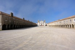 Cape Espichel is a very old place of pilgrimage. The present christian cult, however, began with a miracle, when Our Lady appeared in 1410, climbing the cliffs on a mule, where you can still see the footprints of the animal, as the legend says. Science has a diferent opinion about the footprints: they are from dinosaurs. Cape Espichel is a very old place of pilgrimage. The present christian cult, however, began with a miracle, when Our Lady appeared in 1410, climbing the cliffs on a mule, where you can still see the footprints of the animal, as the legend says. Science has a diferent opinion about the footprints: they are from dinosaurs.
The growing popularity of this sanctuary justified the building, by the pilgrims, of the houses (hospedarias) that, with the church, define the square protected from the winds. The king himself has financed the church and built here a theatre and a Water House in italian style.
|
Coordinates:
38 25 12.05 N 9 12 55 51 W [try copy/paste on Google Earth]
Santiago Church
 Church from the 16th century, in the transition between 'manuelino' (Portuguese gothic) and renaissance styles. It is the main church of Sesimbra. Recently an old lateral door was unveiled under the exterior plaster (see photo). Church from the 16th century, in the transition between 'manuelino' (Portuguese gothic) and renaissance styles. It is the main church of Sesimbra. Recently an old lateral door was unveiled under the exterior plaster (see photo).
(see note below about Santiago) |
Coordinates:
38 26 40.61 N 9 06 08.77 W [try copy/paste on Google Earth]
Chapel of the Holy Spirit of Seamen

The Chapel and hospital of the Holy Spirit of Seamen of Sesimbra was built by the end of 15th century, both dedicated to charity and spiritual assistance to the seamen. In the present it is a museum of religious art.
|
Coordinates:
38 26 37.96 N 9 07 00.73 W [try copy/paste on Google Earth]
Fortress of Santiago

Fortress dating from the 17th century, built under the orientation of jesuit father John Cosmander, of flemish origin.
(see note below about Santiago)
|
Coordinates:
38 26 34.34 N 9 06 04.25 W [try copy/paste on Google Earth]
Church of Mercy
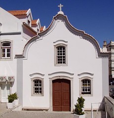 Church of the Holy House of Mercy, built in the begining of 16th century. Inside there is the image of Jesus of Wounds, a wooden statue that appeared on the beach, brought by the sea. Some people propose that it might be one of the images that were thrown to the sea in England, during the protestant Reform. Church of the Holy House of Mercy, built in the begining of 16th century. Inside there is the image of Jesus of Wounds, a wooden statue that appeared on the beach, brought by the sea. Some people propose that it might be one of the images that were thrown to the sea in England, during the protestant Reform.
|
Coordinates:
38 26 39.71 N 9 06 02.76 W [try copy/paste on Google Earth]
Church of Holly Mary of the Castle
 The first church inside Sesimbra castle was built in 1165. The present church was rebuilt in 1721. The painting in the altar represents the Coronation of the Virgin. The interior walls are covered with blue tiles of good quality, representing scenes of the life of the Virgin. The first church inside Sesimbra castle was built in 1165. The present church was rebuilt in 1721. The painting in the altar represents the Coronation of the Virgin. The interior walls are covered with blue tiles of good quality, representing scenes of the life of the Virgin.
|
Coordinates:
38 27 05.84 N 9 06 29.23 W [try copy/paste on Google Earth]
Church of Our Lady of Conception, at Alfarim

Modest temple from the 16th century, built by the population. It is the home of the anual procession of 26 December.
|
Coordinates:
38 28 37.56 N 9 09 38.54 W [try copy/paste on Google Earth]
Palace of Calhariz
 Rural palace, in the transition from the maneiristic to the baroque styles. Built beetwen 1670 and 1710. The palace includes a baroque chapel. Traditionaly owned by the Duques of Palmela, that played an important role in the liberal revolution of 1820. Rural palace, in the transition from the maneiristic to the baroque styles. Built beetwen 1670 and 1710. The palace includes a baroque chapel. Traditionaly owned by the Duques of Palmela, that played an important role in the liberal revolution of 1820.
|
Coordinates:
38 27 47.62 N 9 03 23.17 W [try copy/paste on Google Earth]
Casal do Desembargador

Rural building on the Lands of Calhariz.
|
Coordinates:
38 28 20.24 N 9 02 17.49 W [try copy/paste on Google Earth]
Palace of Sampaio
 Aristocratic house from the 18th century, built by the 1st Count of Sao Payo, D. António de Lusignan. Includes a chapel and decoration with rocaille tiles. It is the location of the anual festivities of Our Lady of Light, each September. It is also dedicated to rural tourism. Aristocratic house from the 18th century, built by the 1st Count of Sao Payo, D. António de Lusignan. Includes a chapel and decoration with rocaille tiles. It is the location of the anual festivities of Our Lady of Light, each September. It is also dedicated to rural tourism.
|
Coordinates:
38 27 57.61 N 9 05 43.94 W [try copy/paste on Google Earth]
Palace of Perú
 Residence of the 18th century, built by industrialist Antonio Cremer, that in 1725 obtained the royal concession for producing gunpowder for the kingdom, at Lisbon. The original building was destroyed by fire, and the present building dates from the 20th century. Residence of the 18th century, built by industrialist Antonio Cremer, that in 1725 obtained the royal concession for producing gunpowder for the kingdom, at Lisbon. The original building was destroyed by fire, and the present building dates from the 20th century. |
Coordinates:
38 31 18.14 N 9 03 37.10 W [try copy/paste on Google Earth]
Solar da Quintinha

Baroque house, located at Cotovia. Includes a private chapel dating from 1738.
|
Coordinates:
38 28 23.59 N 9 06 15.08 W [try copy/paste on Google Earth]
Fortress of S. Teodósio

The fortress of S. Teodósio, also named fortress of the Horse, after the name of the place, was built in 1652. It includes also a lighthouse.
|
Coordinates:
38 26 05.21 N 9 07 00.73 W [try copy/paste on Google Earth]
Cape Espichel Lighthouse
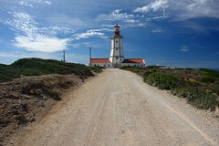
Cape Espichel lighthouse was built in 1790. In the begining olive oil was used for the ilumination. Later it was used a incandescent oil vapor lamp. At the present it works with electricity.
|
Coordinates:
38 24 54.97 N 9 12 59.70 W [try copy/paste on Google Earth]
Quinta da Confeiteira

Rural farm, located at Venda Nova. |
Chapel of Aiana

Chapel of St. John the Baptist, at Aiana. It belonged to the rural farm of Aiana de Baixo, property of Viscount of Asseca. |
Quinta da Ferraria

Ruins of a rural farm at Ferraria Rivulet. This window is in gothic style.
|
Coordinates:
38 30 31 N 9 07 44 W
Note:Santiago is Saint James:
a) From Hebrew to English:
Yahaqob (Hebrew) → Jacomus (Latin) → James, or Jacques (French) → James (English)
b) From Hebrew to Portuguese:
Yahaqob (Hebrew) → Jacomus (Latin) → Iago (Portuguese, like Welsh/Celtic), and then:
Santo Iago → Sant'Iago → Santiago
In medieval times (1236) all this region was given by the king to the religious Order of Santiago (
Order of St. James of the Sword), who provided security and administration, so this is a word you will find in some monuments and toponomy, as well as the symbol of the Order, something between a cross and a sword:

Another recurrent image in monuments is the shell, symbol of pilgrimage, also associated to St. James as a pilgrim, and to the traditional pilgrimage to Compostela. One of the 'Caminhos de Santiago' (
Way of St. James) passes through Cape Espichel.


